
National Remote Sensing Day – History, Facts, Significance & Impact
Introduction
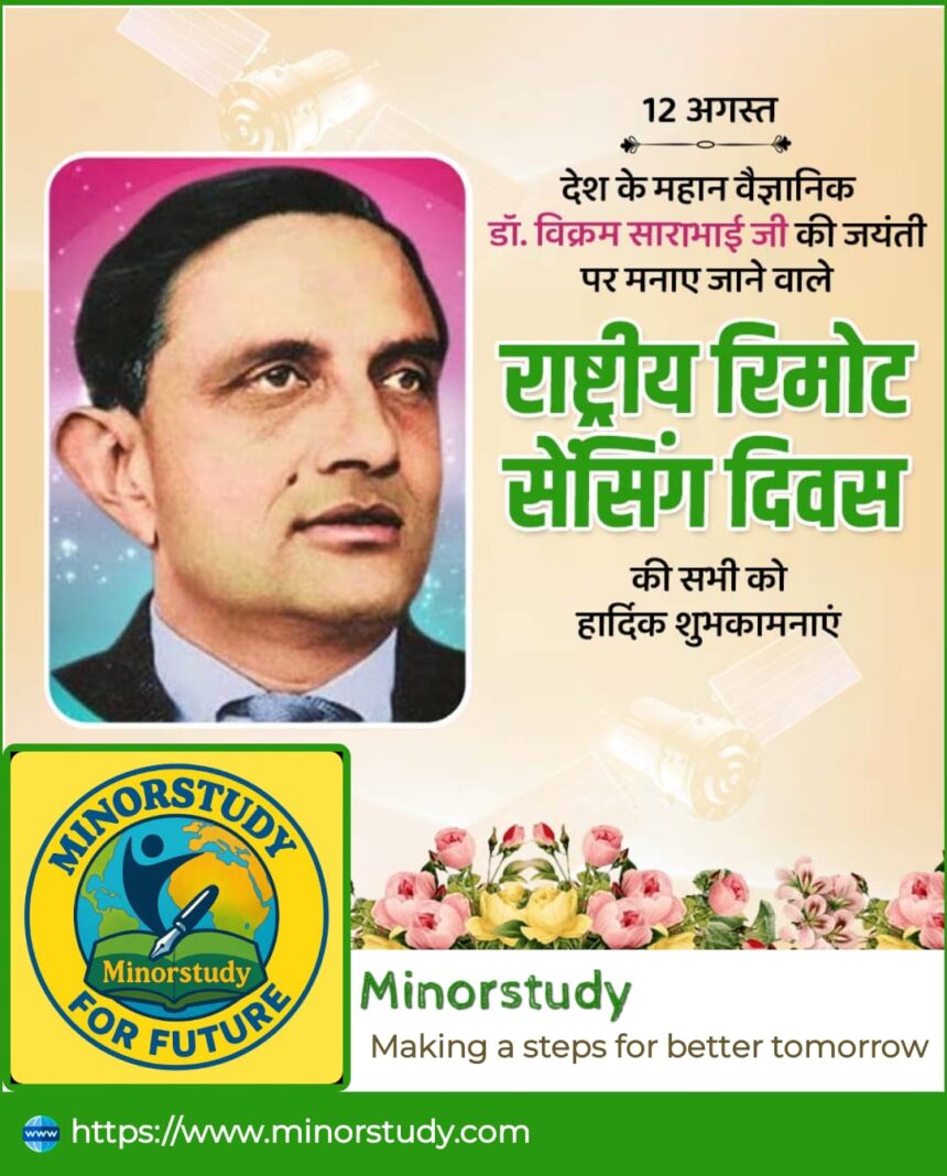
National Remote Sensing Day is one of those observances that beautifully blends science, technology, and national pride. Celebrated every year in India, it commemorates the contributions of Dr. Vikram Sarabhai, the visionary father of India’s space program, and promotes awareness about remote sensing technology—a tool that has transformed agriculture, disaster management, environmental monitoring, and countless aspects of modern life.
- Introduction
- History of National Remote Sensing Day
- What is Remote Sensing?
- Facts About National Remote Sensing Day
- Timeline of Remote Sensing in India
- Significance of National Remote Sensing Day
- How National Remote Sensing Day is Observed
- Wishing on National Remote Sensing Day
- Important Points to Remember
- Impact on Our Daily Lives
- Importance to Society
- FAQs – National Remote Sensing Day
- Conclusion
In an era where satellites help predict cyclones, guide farmers, track forest cover, and even detect illegal mining, this day reminds us how far India has come in the realm of space-based Earth observation.
History of National Remote Sensing Day
The history of National Remote Sensing Day is closely tied to India’s space journey.
Why it is celebrated: It is observed on August 12, the birth anniversary of Dr. Vikram Sarabhai (1919–1971).
Who initiated it: The Indian Space Research Organisation (ISRO) and the Department of Space decided to mark this day to honor his immense contribution to India’s satellite technology and remote sensing program.
First Celebration: Official celebrations began in the late 1980s and early 1990s as India’s remote sensing satellites started operational work.
Dr. Sarabhai’s Vision: He believed India must harness space technology for nation-building, especially in agriculture, weather forecasting, and rural development. His vision led to the launch of India’s IRS (Indian Remote Sensing) satellite series.
What is Remote Sensing?
Remote sensing is the science of gathering information about the Earth’s surface without physically touching it—usually with satellites or aircraft.
It involves:
Satellite imagery
Aerial photography
Data interpretation using sensors
In simple terms, remote sensing is like having “eyes in the sky” to study Earth’s environment and resources.
Facts About National Remote Sensing Day
Here are some fascinating facts about this special day and the technology it celebrates:
Date – Observed annually on August 12.
Honors a Pioneer – Celebrates Dr. Vikram Sarabhai’s birthday.
First IRS Satellite – IRS-1A, launched in 1988, marked the beginning of India’s operational remote sensing program.
Global Rank – India is among the top nations in remote sensing technology.
Key Applications – Used in agriculture, urban planning, water resource management, forestry, and disaster response.
ISRO’s Contribution – Operates one of the largest constellations of remote sensing satellites in the world.
Open Data Policy – ISRO provides remote sensing data for research, development, and planning.
Timeline of Remote Sensing in India
| Year | Event |
|---|---|
| 1960s | Dr. Vikram Sarabhai envisions using satellites for development. |
| 1975 | Launch of Aryabhata, India’s first satellite. |
| 1988 | Launch of IRS-1A, the first operational Indian Remote Sensing satellite. |
| 1995 | Remote Sensing applications become part of national planning. |
| 2000s | High-resolution satellites like Cartosat are launched. |
| 2013 | Launch of Resourcesat-2A for agricultural and environmental monitoring. |
| Present | ISRO operates a large fleet of Earth observation satellites serving global needs. |
Significance of National Remote Sensing Day
Scientific Awareness – Encourages understanding of space-based technology.
National Pride – Showcases India’s space achievements.
Policy Making – Remote sensing data helps governments plan better infrastructure and disaster response.
Economic Impact – Saves billions by improving crop yields, reducing losses, and managing natural resources.
Educational Importance – Inspires students to explore careers in space science.
How National Remote Sensing Day is Observed
Seminars & Workshops – ISRO conducts lectures on remote sensing applications.
Student Engagement – Schools and colleges organize quiz competitions, exhibitions, and science fairs.
Awareness Drives – Government agencies showcase how satellite imagery benefits everyday life.
Public Outreach – Documentaries and news programs highlight India’s achievements in remote sensing.
Wishing on National Remote Sensing Day
Here are a few heartfelt wishes you can share:
🌍 “On National Remote Sensing Day, let’s salute the technology that helps us understand and protect our planet.”
🚀 “Wishing you a day filled with pride for our nation’s achievements in space and remote sensing!”
🌱 “May the vision of Dr. Vikram Sarabhai inspire us to use technology for the betterment of humanity.”
Important Points to Remember
Date: 12 August
Significance: Honors Dr. Vikram Sarabhai & promotes remote sensing awareness.
First IRS Satellite: IRS-1A (1988).
Uses: Agriculture, disaster management, environment monitoring, urban planning.
Organizing Body: ISRO & Department of Space.
Impact on Our Daily Lives
Even if you don’t directly interact with satellites, remote sensing technology is silently shaping your everyday life:
Weather Forecasts – Predicts rainfall, storms, and heatwaves.
Disaster Warnings – Alerts for cyclones, floods, and earthquakes.
Food Security – Monitors crops to ensure enough food supply.
Clean Water – Tracks water bodies for quality and quantity.
Urban Growth – Helps design smarter cities.
Importance to Society
Remote sensing isn’t just a technical achievement—it’s a social asset:
Helps farmers increase productivity.
Protects wildlife and forests.
Manages natural resources efficiently.
Supports climate change research.
FAQs – National Remote Sensing Day
Q1. When is National Remote Sensing Day celebrated?
A: On August 12 every year.
Q2. Who is honored on this day?
A: Dr. Vikram Sarabhai, the father of India’s space program.
Q3. Which was India’s first remote sensing satellite?
A: IRS-1A, launched in 1988.
Q4. What are some uses of remote sensing?
A: Agriculture, forestry, urban planning, weather monitoring, and disaster management.
Q5. Who manages remote sensing satellites in India?
A: The Indian Space Research Organisation (ISRO).
Conclusion
National Remote Sensing Day is not just about honoring a great scientist—it’s about recognizing how far India has come in using space technology for national development. It reminds us of our responsibility to use science for the welfare of humanity.
From Dr. Vikram Sarabhai’s vision to ISRO’s world-class satellite programs, this journey inspires millions of students, scientists, and dreamers. As we move forward, remote sensing will play an even bigger role in solving global challenges like climate change, food security, and disaster resilience.
So, the next time you check the weather forecast or read about a cyclone warning, remember—the technology that made it possible is exactly what we celebrate on National Remote Sensing Day.


